|
|
| Line 67: |
Line 67: |
| | |coordinates_display = inline,title | | |coordinates_display = inline,title |
| | |coordinates_type = region:US_type:city | | |coordinates_type = region:US_type:city |
| − | |latd = 40
| |
| − | |latm = 12
| |
| − | |lats = 16
| |
| − | |latNS = N
| |
| − | |longd = 79
| |
| − | |longm = 36
| |
| − | |longs = 58
| |
| − | |longEW = W
| |
| − | |elevation_footnotes =
| |
| − | |elevation_m =
| |
| − | |elevation_ft = 994
| |
| − | |postal_code_type = [[wikipedia:Zip code|Zip code]]
| |
| − | |postal_code = 15639
| |
| − | |area_code =
| |
| − | |website =
| |
| − | |footnotes =
| |
| − | }}
| |
| − | {{Infobox settlement
| |
| − | |official_name = Hunker, Pennsylvania
| |
| − | |other_name =
| |
| − | |native_name =
| |
| − | |nickname =
| |
| − | |settlement_type = Borough
| |
| − | |motto =
| |
| − | |image_skyline = Hunker Pennsylvania 2010.jpg
| |
| − | |imagesize =
| |
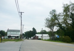
| − | |image_caption = Bridge Street
| |
| − | |image_flag =
| |
| − | |flag_size =
| |
| − | |image_seal =
| |
| − | |seal_size =
| |
| − | |image_shield =
| |
| − | |shield_size =
| |
| − | |image_blank_emblem =
| |
| − | |blank_emblem_size =
| |
| − | |pushpin_map = Pennsylvania
| |
| − | |pushpin_label_position = right<!-- the position of the pushpin label: left, right, top, bottom, none -->
| |
| − | |pushpin_map_caption =
| |
| − | |pushpin_mapsize =
| |
| − | <!-- Location ------------------>
| |
| − | |subdivision_type = [[wikipedia:List of countries|Country]]
| |
| − | |subdivision_name = [[wikipedia:United States|United States]]
| |
| − | |subdivision_type1 = [[wikipedia:US state|State]]
| |
| − | |subdivision_name1 = [[wikipedia:Pennsylvania|Pennsylvania]]
| |
| − | |subdivision_type2 = [[wikipedia:List of counties in Pennsylvania|County]]
| |
| − | |subdivision_name2 = [[wikipedia:Westmoreland County, Pennsylvania|Westmoreland]]
| |
| − | |government_footnotes =
| |
| − | |government_type = Borough Council
| |
| − | |leader_title = Mayor
| |
| − | |leader_name =
| |
| − | |leader_title1 =
| |
| − | |leader_name1 =
| |
| − | |leader_title2 =
| |
| − | |leader_name2 =
| |
| − | |leader_title3 =
| |
| − | |leader_name3 =
| |
| − | |leader_title4 =
| |
| − | |leader_name4 =
| |
| − | |established_title = Settled
| |
| − | |established_date = 1903
| |
| − | |established_title1 = Incorporated
| |
| − | |established_date1 = 1929
| |
| − | |area_magnitude =
| |
| − | |unit_pref =
| |
| − | |unit_pref = Imperial
| |
| − | |area_footnotes =
| |
| − | |area_total_km2 =
| |
| − | |area_land_km2 =
| |
| − | |area_water_km2 =
| |
| − | |area_total_sq_mi = 0.4
| |
| − | |area_land_sq_mi =
| |
| − | |area_water_sq_mi =
| |
| − | |area_water_percent =
| |
| − | |population_as_of = 2000
| |
| − | |population_footnotes =
| |
| − | |population_note =
| |
| − | |population_total = 329
| |
| − | |population_density_km2 =
| |
| − | |population_density_sq_mi = 886.8
| |
| − | |timezone = [[wikipedia:Eastern Time Zone|Eastern (EST)]]
| |
| − | |utc_offset = -5
| |
| − | |timezone_DST = EDT
| |
| − | |utc_offset_DST = -4
| |
| − | |coordinates_display = inline,title
| |
| − | |coordinates_type = region:US_type:city
| |
| − | |latd = 40
| |
| − | |latm = 12
| |
| − | |lats = 16
| |
| − | |latNS = N
| |
| − | |longd = 79
| |
| − | |longm = 36
| |
| − | |longs = 58
| |
| − | |longEW = W
| |
| | |elevation_footnotes = | | |elevation_footnotes = |
| | |elevation_m = | | |elevation_m = |
| Line 169: |
Line 76: |
| | |footnotes = | | |footnotes = |
| | }} | | }} |
| | + | |
| | + | |
| | | | |
| | | | |
