Difference between revisions of "Upper Fairfield Township, Lycoming County, Pennsylvania"
| Line 65: | Line 65: | ||
|timezone_DST = EDT | |timezone_DST = EDT | ||
|utc_offset_DST = -4 | |utc_offset_DST = -4 | ||
| − | |elevation_footnotes = | + | |elevation_footnotes = |
|elevation_m = 273 | |elevation_m = 273 | ||
|elevation_ft = 896 | |elevation_ft = 896 | ||
| Line 72: | Line 72: | ||
|area_code = | |area_code = | ||
|blank_name = [[wikipedia:Federal Information Processing Standard|FIPS code]] | |blank_name = [[wikipedia:Federal Information Processing Standard|FIPS code]] | ||
| − | |blank_info = | + | |blank_info = |
|blank1_name = [[wikipedia:Geographic Names Information System|GNIS]] feature ID | |blank1_name = [[wikipedia:Geographic Names Information System|GNIS]] feature ID | ||
| − | |blank1_info = | + | |blank1_info = |
|website = | |website = | ||
|footnotes = | |footnotes = | ||
Revision as of 22:34, 8 May 2014
| Upper Fairfield Township, Lycoming County, Pennsylvania | |
|---|---|
| Township | |
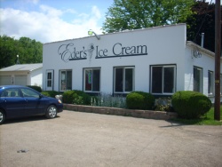
 Eder's Ice Cream in Upper Fairfield Township | |
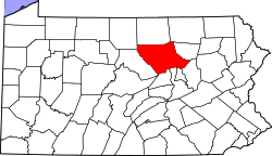
 Map of Lycoming County, Pennsylvania highlighting Upper Fairfield Township | |
 Map of Lycoming County, Pennsylvania | |
| Country | United States |
| State | Pennsylvania |
| County | Lycoming |
| Settled | 1800 |
| Incorporated | 1851 |
| Area | |
| • Total | 18.2 sq mi (47.2 km2) |
| • Land | 18.1 sq mi (46.9 km2) |
| • Water | 0.1 sq mi (0.3 km2) |
| Elevation | 896 ft (273 m) |
| Population (2000) | |
| • Total | 1,854 |
| • Density | 102.4/sq mi (39.5/km2) |
| Time zone | Eastern (EST) (UTC-5) |
| • Summer (DST) | EDT (UTC-4) |
Municipality Details
Oil and Gas Activity
| Well ID | Operator Name | First Permit Date | Spud Date | Unconventional | Horizontal | Producing | Violations |
|---|---|---|---|---|---|---|---|
| 081-20113 | CHIEF OIL & GAS LLC | 2008-05-20 | None | Y | N | ACTIVE | None |
| 081-20117 | CHIEF OIL & GAS LLC | 2008-06-20 | None | Y | N | ACTIVE | None |
| 081-20177 | RICE DRILLING B LLC | 2009-08-13 | None | Y | N | ACTIVE | None |
| 081-20177 | RICE DRILLING B LLC | 2009-08-13 | None | Y | N | INACTIVE | None |
| 081-20178 | RICE DRILLING B LLC | 2009-09-15 | 2009-11-17 | Y | N | ACTIVE | 9 |
| 081-20227 | RICE DRILLING B LLC | 2009-12-22 | None | Y | N | ACTIVE | None |
| 081-20227 | RICE DRILLING B LLC | 2009-12-22 | None | Y | N | INACTIVE | None |
| 081-20228 | RICE DRILLING B LLC | 2009-12-23 | None | Y | N | ACTIVE | None |
| 081-20228 | RICE DRILLING B LLC | 2009-12-23 | None | Y | N | INACTIVE | None |
| 081-20784 | INFLECTION ENERGY LLC | 2012-02-15 | 2013-02-12 | Y | N | ACTIVE | None |
| 081-20795 | INFLECTION ENERGY LLC | 2012-02-28 | 2012-07-31 | Y | Y | PBNM | None |
| 081-20795 | INFLECTION ENERGY LLC | 2012-02-28 | 2012-07-31 | Y | Y | ACTIVE | None |
| 081-20920 | INFLECTION ENERGY LLC | 2012-03-30 | 2012-10-16 | Y | Y | ACTIVE | None |
| 081-20921 | INFLECTION ENERGY LLC | 2012-03-30 | 2012-10-17 | Y | Y | ACTIVE | None |
| 081-20922 | INFLECTION ENERGY LLC | 2012-03-21 | 2012-07-30 | Y | Y | ACTIVE | None |
| 081-20923 | INFLECTION ENERGY LLC | 2012-03-22 | 2013-02-14 | Y | Y | ACTIVE | None |