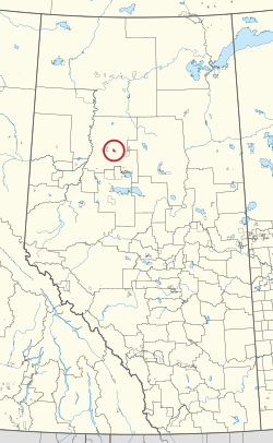
Woodland Cree 228, Alberta
| Woodland Cree 228 | |
|---|---|
| Indian reserve | |
| Woodland Cree Indian Reserve No. 228 | |
 | |
| First Nation | Woodland Cree |
| Treaty | 8 |
| Country | Canada |
| Province | Alberta |
| Municipal district | Northern Sunrise |
| Area | |
| • Total | 3,786 ha (9,355 acres) |
| Population (2016) | |
| • Total | 150 |
| • Density | 4.0/km2 (10/sq mi) |
| For infobox source see[1] | |
Contents
Municipality Well Data
| UWI | Well Name | Operator Name | License Number | License Issue Date | License Status | Spud Date |
|---|---|---|---|---|---|---|
| 0865131910000 | REDEARTH GOLDEN 10-19-86-13 | Harvest Operations Corp. | 0226484 | 1999-09-20 | Suspension | 1999-10-01 |
| 0865132113000 | REDEARTH ET AL EVI 13-21-86-13 | Harvest Operations Corp. | 0233747 | 2000-02-14 | Suspension | 2000-03-19 |
| 0865132904000 | PEX EVI 4-29-86-13 | Suncor Energy Inc. | 0100552 | 1983-02-11 | RecCertified | 1983-02-20 |
| 0865133006000 | BP EVI 6-30-86-13 | Repsol Oil & Gas Canada Inc. | 0103471 | 1983-10-07 | RecCertified | 1983-10-27 |
| 0865142407000 | HESS ET AL EVI 7-24-86-14 | 177293 Canada Ltd. | 0119683 | 1985-11-26 | RecCertified | 1985-12-14 |
| 0865142605000 | TOTAL GOLDEN 5-26-86-14 | Repsol Oil & Gas Canada Inc. | 0056433 | 1976-01-05 | RecExempt | 1976-01-07 |
| 0865143616000 | PENN WEST ET AL GOLDEN 16-36-86-14 | Obsidian Energy Ltd. | 0282017 | 2003-02-03 | Abandoned | 2003-02-19 |
| 0875140210000 | PCI GOLDEN 10-2-87-14 | Suncor Energy Inc. | 0104404 | 1983-11-29 | RecCertified | 1983-12-07 |
References
- ↑ "Woodland Cree 228". Wikipedia. Retrieved 2021-01-15.
- ↑ "General Well Data File - Licensing Data". Alberta Energy Regulator. 2020-04-22. Retrieved 2020-05-07.
- ↑ "General Well Data File - Drilling Data". Alberta Energy Regulator. 2020-04-22. Retrieved 2020-05-07.