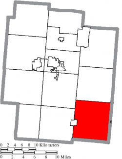
Marion Township, Henry County, Ohio
| Madison Township, Jackson County, Ohio | |
|---|---|
| Township | |
 Location of Madison Township in Jackson County | |
| Country | United States |
| State | Ohio |
| County | Jackson |
| Area | |
| • Total | 45.4 sq mi (117.6 km2) |
| • Land | 45.3 sq mi (117.3 km2) |
| • Water | 0.1 sq mi (0.3 km2) |
| Elevation | 794 ft (242 m) |
| Population (2010) | |
| • Total | 2,188 |
| • Density | 48.2/sq mi (18.6/km2) |
| Time zone | Eastern (EST) (UTC-5) |
| • Summer (DST) | EDT (UTC-4) |
| For infobox source see[1] | |
Contents
Municipality Well Data
| Well ID | Operator Name | Permit Date | Spud Date | Configuration | License Status |
|---|---|---|---|---|---|
| 34-069-20001 | HISTORIC OWNER | 1934-07-02 | Vertical | Plugged and Abandoned | |
| 34-069-20013 | HISTORIC OWNER | Vertical | Plugged and Abandoned | ||
| 34-069-20015 | HISTORIC OWNER | Vertical | Plugged and Abandoned | ||
| 34-069-20023 | ROCKWELL OIL COMPANY | 1965-09-03 | 1965-09-04 | Vertical | Producing |
| 34-069-20024 | HISTORIC OWNER | 1965-12-16 | 1965-12-09 | Vertical | Field Inspected: Well Not Found |
| 34-069-20025 | HISTORIC OWNER | 1965-12-16 | Vertical | Not Drilled | |
| 34-069-20028 | HISTORIC OWNER | 1968-08-01 | 1968-08-06 | Vertical | Plugged and Abandoned |
| 34-069-20029 | ROCKWELL OIL COMPANY | 1968-09-04 | 1968-09-03 | Vertical | Producing |
| 34-069-20030 | BRUBAKER FRANCIS & MARY | 1970-05-28 | 1970-06-04 | Vertical | Domestic Well |
| 34-069-20031 | HISTORIC OWNER | 1970-08-19 | 1970-11-01 | Vertical | Plugged and Abandoned |
| 34-069-20032 | HISTORIC OWNER | 1970-10-14 | 1970-10-14 | Vertical | Plugged and Abandoned |
| 34-069-20054 | GRAHAM MICHAELIS CORP | 1975-06-30 | Vertical | Not Drilled | |
| 34-069-20122 | DUSTY DRILLING & PRODUCING COR | 1987-09-15 | 1981-06-25 | Vertical | Final Restoration |
| 34-069-20125 | DUSTY DRILLING & PRODUCING COR | 1987-09-15 | 1981-05-04 | Vertical | Final Restoration |
| 34-069-20129 | FITZGERALD ENERGY PRODUC | 1982-09-09 | 1983-02-25 | Vertical | Final Restoration |
| 34-069-20131 | ASHLAND DRILLING CO INC | 1986-12-31 | 1982-10-05 | Vertical | Final Restoration |
| 34-069-20135 | HISTORIC OWNER | 1987-01-17 | Vertical | Not Drilled | |
| 34-069-20138 | MILES LOUISE | 1999-11-19 | Vertical | Not Drilled | |
| 34-069-60019 | HISTORIC OWNER | Vertical | Historical Production Well | ||
| 34-069-60020 | HISTORIC OWNER | Vertical | Historical Production Well | ||
| 34-069-60021 | HISTORIC OWNER | 1900-01-01 | Vertical | Historical Production Well | |
| 34-069-60022 | HISTORIC OWNER | 1900-01-01 | Vertical | Historical Production Well | |
| 34-069-60023 | HISTORIC OWNER | Vertical | Historical Production Well | ||
| 34-069-60024 | HISTORIC OWNER | 1900-01-01 | Vertical | Historical Production Well | |
| 34-069-60025 | HISTORIC OWNER | 1900-01-01 | Vertical | Plugged and Abandoned | |
| 34-069-60026 | HISTORIC OWNER | 1900-01-01 | Vertical | Historical Production Well | |
| 34-069-60027 | HISTORIC OWNER | 1900-01-01 | Vertical | Historical Production Well | |
| 34-069-60028 | HISTORIC OWNER | 1900-01-01 | Vertical | Historical Production Well | |
| 34-069-60029 | HISTORIC OWNER | Vertical | Plugged and Abandoned | ||
| 34-069-60032 | HISTORIC OWNER | 1944-01-01 | Vertical | Historical Production Well | |
| 34-069-60049 | HISTORIC OWNER | Vertical | Not Drilled | ||
| 34-069-60060 | HISTORIC OWNER | Vertical | Not Drilled | ||
| 34-069-60070 | HISTORIC OWNER | 1900-01-01 | Vertical | Historical Production Well | |
| 34-069-60071 | HISTORIC OWNER | 1900-01-01 | Vertical | Plugged and Abandoned |
For data sources see[2]
References
- ↑ "Madison Township, Jackson County, Ohio#". Wikipedia. Retrieved 2021-01-11.
- ↑ "Risk Based Data Management System". Ohio Department of Natural Resources. 2020-11-16. Retrieved 2020-11-16.