Vinton Township, Vinton County, Ohio
| Union Township, Auglaize County, Ohio | |
|---|---|
| Township | |
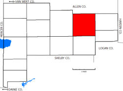
 Location of Union Township in Auglaize County | |
| Country | United States |
| State | Ohio |
| County | Auglaize |
| Area | |
| • Total | 35.9 sq mi (92.9 km2) |
| • Land | 35.9 sq mi (92.9 km2) |
| • Water | 0.0 sq mi (0.0 km2) |
| Elevation | 955 ft (291 m) |
| Population (2010) | |
| • Total | 1,902 |
| • Density | 53/sq mi (20.5/km2) |
| Time zone | Eastern (EST) (UTC-5) |
| • Summer (DST) | EDT (UTC-4) |
| For infobox source see[1] | |
Contents
Municipality Well Data
| Well ID | Operator Name | Permit Date | Spud Date | Configuration | License Status |
|---|---|---|---|---|---|
| 34-163-20063 | HISTORIC OWNER | 1952-10-25 | Vertical | Orphan Well - Ready | |
| 34-163-20064 | HISTORIC OWNER | 1953-01-28 | Vertical | Plugged and Abandoned | |
| 34-163-20331 | HISTORIC OWNER | 1967-01-05 | 1967-01-06 | Vertical | Dry and Abandoned |
| 34-163-20338 | HISTORIC OWNER | 1967-06-15 | 1967-06-22 | Vertical | Plugged and Abandoned |
| 34-163-20375 | STEWART PRODUCERS | 1972-03-01 | Vertical | Not Drilled | |
| 34-163-20389 | HOCKING HILLS ENERGY AND WELL | 1986-05-09 | 1977-10-18 | Vertical | Dry and Abandoned |
| 34-163-20392 | INLAND DRILLING CO INC | 1978-12-29 | Vertical | Not Drilled | |
| 34-163-20393 | INLAND DRILLING CO INC | 1978-12-29 | Vertical | Not Drilled | |
| 34-163-20552 | PATTON NOLA & WARREN | 1981-03-17 | 1900-01-01 | Vertical | Domestic Well |
| 34-163-20791 | PIP PETROLEUM | 1985-10-11 | 1982-11-12 | Vertical | Final Restoration |
| 34-163-20792 | PIP PETROLEUM | 1988-05-12 | 1982-11-10 | Vertical | Final Restoration |
| 34-163-20793 | PIP PETROLEUM | 1982-10-26 | Vertical | Not Drilled | |
| 34-163-20924 | CHESAPEAKE APPALACHIA LLC | 2000-01-27 | 2000-03-06 | Directional | Final Restoration |
| 34-163-20945 | OXFORD OIL | 2008-06-04 | Vertical | Not Drilled | |
| 34-163-60096 | HISTORIC OWNER | 1900-01-01 | Vertical | Plugged and Abandoned | |
| 34-163-60484 | HISTORIC OWNER | Vertical | Historical Production Well | ||
| 34-163-60485 | HISTORIC OWNER | 1900-01-01 | Vertical | Historical Production Well | |
| 34-163-60516 | HISTORIC OWNER | Vertical | Plugged and Abandoned | ||
| 34-163-60887 | HISTORIC OWNER | 1900-01-01 | Vertical | Unknown status | |
| 34-163-60889 | HISTORIC OWNER | Vertical | Plugged and Abandoned | ||
| 34-163-60890 | HISTORIC OWNER | Vertical | Plugged and Abandoned | ||
| 34-163-60891 | HISTORIC OWNER | Vertical | Orphan Well - Ready | ||
| 34-163-90193 | HISTORIC OWNER | Vertical | Unknown status | ||
| 34-163-90196 | HISTORIC OWNER | Vertical | Unknown status |
For data sources see[2]
References
- ↑ "Union Township, Auglaize County, Ohio#". Wikipedia. Retrieved 2021-01-12.
- ↑ "Risk Based Data Management System". Ohio Department of Natural Resources. 2020-11-16. Retrieved 2020-11-16.